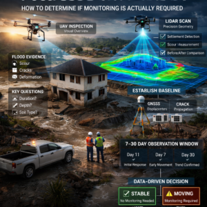
In the previous post, I discussed the recent flooding event in Hawaii and, more broadly, where systems like infrascan can provide value.
But there is a more practical and important question:
How do you actually determine whether post-flood monitoring is required or not?
So the correct engineering approach is not to “install sensors by default”, but to first determine:
whether there is a reasonable basis to expect post-event degradation over time
1. Initial assessment
The first step is not monitoring – it is understanding what actually happened to the asset.This includes evaluating:
– duration of water exposure
– flood depth
– evidence of scour near the foundation
– local terrain deformation
– cracks, misalignment, or structural irregularities
– soil type and foundation conditions
At this stage, UAV-based inspection is commonly used. Its purpose is to provide a rapid spatial overview:
– identify potential risk zones
– detect surface changes
– assess possible erosion or washout
However, it is important to recognize:
UAV imagery provides visual context, not precise geometry
2. Why LiDAR is often critical
If the objective is to understand actual geometric changes to the site and foundation, visual inspection alone is not sufficient.
After a flood, the primary risks are geometric in nature:
-localized settlement
– loss of soil volume
– slope and grade changes
– foundation scour
– deformation of embankments or support zones
These changes are often:
– not clearly visible
– masked by debris or sediment
– visually misleading in standard imagery
This is where LiDAR becomes highly valuable.
LiDAR provides:
– accurate 3D surface geometry
– detection of subtle terrain deformation
-the ability to perform before/after comparisons
– quantitative assessment of surface changes
3. Transition to monitoring
UAV and LiDAR answer the question:
what has happened
But the critical post-flood question is:
is the asset continuing to change
If any risk indicators are present, the next step is to establish a baseline.
4. Instrumented observation
At this stage, monitoring begins.
GNSS (primary method)
Used for:
– tracking displacement
– controlling reference points
– detecting even small positional changes
GNSS is appropriate when there is a risk of:
– foundation movement
– differential settlement
– instability of the support system
Additional instrumentation
Tilt sensors → for inclination or rotational movement
Crack sensors → for tracking crack propagation
5. Observation period
The critical observation window is typically 7–30 days.
0–24 hours → initial response
1–7 days → early-stage deformation (settlement, tilt, micro-movement)
7–30 days → trend becomes clear (stabilization vs progression)
this is where the real condition of the asset becomes evident
Conclusion
Monitoring defines the behavior.
And it is the behavior over time that determines whether intervention is required.