


Description
Geotechnical MEMS Tilt Sensor for Long-Term Infrastructure Monitoring
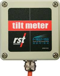
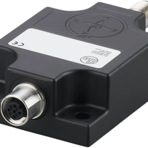
RST DT205 MEMS Tiltmeter is a high-resolution inclination sensor
specifically designed for geotechnical and civil engineering monitoring
applications where long-term stability and low noise performance are critical.
The sensor is optimized for detecting very small angular changes associated with
ground movement, differential settlement, and structural deformation. Its robust
design and stable MEMS technology make it suitable for permanent outdoor
installations.
Measured Parameters
- Tilt / inclination (single or biaxial configuration)
- Slow rotational movement
- Long-term deformation trends
Typical Accuracy
- Resolution: up to 0.001°
- High repeatability and low noise
- Excellent long-term stability
Sensor Capabilities
- MEMS-based tilt measurement technology
- Designed for geotechnical and civil monitoring
- Optimized for static and quasi-static measurements
- Continuous 24/7 operation
Data Output & Integration
- Analog or digital output (model-dependent)
- Compatible with data loggers and monitoring systems
- Suitable for long-term unattended installations
- Compatible with monitoring dashboards and SHM platforms
Typical Applications
- Embankments and slopes
- Dams and earth structures
- Retaining walls and excavations
- Foundations and ground settlement monitoring
InfraScan Integration
RST DT205 MEMS Tiltmeter can be integrated into InfraScan monitoring systems to
provide high-resolution tilt data, long-term trend analysis, and automated alerts
for early detection of ground and structural movement.
The sensor is commonly deployed together with GNSS displacement monitoring and
crack meters to separate ground-driven deformation from structural response.

Reviews
There are no reviews yet.